
The Data Mosaic for Peace
This blog post highlights a recently published article in The Peace Room Substack, where PeaceEye CEO, Andreas Papp, discusses the vision behind PeaceEye’s Data Integration Platform, particularly its main differentiator, the Local Intelligence Component.
The data mosaic
”
PeaceEye’s architecture starts with Earth Observation data from the Copernicus program, the EU’s satellite constellation. That gives the platform the ability to detect physical changes on the ground, like burned structures, troop movements, population displacement patterns, movement in mines that are allegedly closed, infrastructure damage, and environmental shifts like access to water or changes in land use. This is layered with open-source intelligence, including near-real-time media monitoring and social media sentiment analysis, and AI-driven analytics that fuse these data streams into geospatial risk assessments.
But Papp is the first to say that’s not enough to understand what’s happening on the ground. “Without human intelligence, we would miss one of the most important pieces of information,” he says. “What is going on the ground that we don’t see on satellites.”
This is PeaceEye’s differentiator. Anyone can download a satellite image. Datasets like ACLED and Uppsala Conflict Data Program offer valuable macro-level conflict tracking, and they’re useful for understanding the big picture. But these sources can really only convey context and history. They do not tell you in real time what is happening at the 30-kilometer radius around a specific location like a mine, a humanitarian medical center, or a supply depot. And if conflict erupts or a tsunami hits, these reports will not help your operations team find safe egress routes or help your logistics team re-route supply chains. Lack of access to this kind of critical information often results in work stoppages, supply chain disruptions, or direct physical security risks to staff and communities that are costly to all involved.
The crowdsourcing component that provides this granular data is what sets PeaceEye apart. Local sources report geolocated events and trends through a progressive web app. The information flows into PeaceEye’s data fusion engine, where it is cross-referenced with satellite imagery and open-source intelligence to produce an integrated picture of the operating space. When he described it to me, it reminded me of conflict observatories (e.g., the Ukraine Conflict Observatory at Yale), except with crowdsourced human intelligence and a much wider user base.
”
The article also highlights Peace’Eye’s impact products, including the Farmer/Herder App. It showcases an analytical look at the potential of these initiatives through the lens of the #peacetech community, from technical novelty to investability. The author also highlights specific features of the app in several segments, such as;
Geo-Fencing for Peace in Nigeria
”
To see what this looks like in practice, we’ll focus on Nigeria, where PeaceEye is building a Herders-Farmers App for communities in Ogun State. And the first thing we’ll notice is not the tech solution, but the business approach.
The herder-farmer conflict in Nigeria is one of the deadliest in the world. Climate change (especially desertification) has pushed nomadic herders further south into farming territory, and traditional land-sharing systems have broken down. Thousands of people die each year in cycles of attack and reprisal. In April 2025 alone, over 100 people were killed across Plateau State in intercommunal attacks between herder and farming communities, with the deadliest incidents in the Bokkos and Bassa areas.
”
Highlighting how this app can indeed aid conflict prevention by addressing “assumptions”.
”
“Sometimes we think people don’t know about what’s available,” Papp reflects. “That is a misconception.” It also wasn’t an idea Papp went to Nigeria with, but it became part of the technical solution.
What emerged from those conversations is a tool built around a simple insight: many conflicts start with assumptions. They see a field that looks unused. Or a path that was once open and is assumed to still be open, but now it isn’t. A herd passing through land where permission was never clearly given or denied, it was just always that way, but now it isn’t.
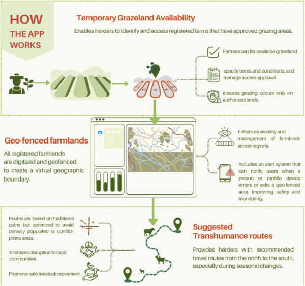
The app addresses these assumptions by making land use visible and shared by all involved. Registered farmlands are digitized and geo-fenced, creating virtual boundaries that both farmers and herders can see. An integrated alert system notifies users when livestock enter or leave a geo-fenced area. Farmers can temporarily list grazing land that is available and set conditions for access. Herders can search for authorized grazing areas and navigate to them using suggested transhumance routes based on traditional paths but refined to avoid high-risk zones.
”
This post contains excerpts from the article “The Data Mosaic for Peace” originally published by Kris Inman on May 07, 2026.
Access the full article here .
#SDG9, #SDG13, #SDG17