Geospatial Risk Analysis
By integrating Earth Observation (EO) data with local human intelligence, media- and open-source intelligence, and AI-driven geospatial risk analytics, we deliver actionable insights into volatile contexts. These insights enable decision-makers to anticipate risks and make strategic decisions.
About us
PeaceEye delivers state-of-the-art solutions by harnessing Earth Observation (EO), Artificial Intelligence (AI), Open-Source Intelligence (OSINT), Human Intelligence (HumINT), and advanced analytics. We support private enterprises, media organizations, international bodies, policymakers, and NGOs, enabling strategic decision making for both commercial and humanitarian operations in volatile regions.
Our mission is to deliver a powerful insight tool for volatile regions, enhancing situational awareness and providing actionable intelligence to help stakeholders better understand conflict dynamics and risk factors. PeaceEye is committed to promoting peacebuilding and resilience, facilitating peaceful transitions, and preventing tensions from escalating. Aligned with the Sustainable Development Goals (SDGs) and Corporate Sustainability Due Diligence Directive (CSDDD), we integrate diverse stakeholders and amplify the voices of those affected by conflict and geospatial risks.
To achieve this, our research and development efforts focus on advancing EO data integration, Natural Language Processing (NLP), and GeoAI to strengthen PeaceEye’s system architecture and impact.
Services

Data Pipeline

GeoKnowledge Graphs

Human Intelligence
Situational Awareness
real-time information provided by verified local stakeholders.
Geospatial risk analysis
an end-to-end geospatial risk assessment platform.
Integrated Tailored Solutions
uniquely crafted fully, integrated solutions.
Support UN SDGs
solutions are crafted to support UN SDG and CSDDD.
Explore More
technology
Partners
PeaceEye partners include University of Salzburg-Z_GIS, Andreas Papp Consulting e.U., Spatial Services, GEOHUM, ESA, FFG and Headline hunter.


Our partners PLUS/Z_GIS and the spin-off company Spatial Services have developed various geospatial and EO-based humanitarian services since 2011. The strong link between research and the market sector creates an ideal environment for developing and operationalising geospatial services. Based on these competencies, there are several services which can be developed with PeaceEye focusing on conflict mapping and peace building.

Vulnerability and resilience analysis
Assess vulnerability of population for planning of mitigation measures.

Flood mapping
Mapping of flooded areas for assessing impact of flood on infrastructure, agriculture to plan recreation.

Humanitarian response
EO-based emergency mapping is invaluable in detecting changes, monitoring progress, and ensuring timely decisions during crises

latest news & insights
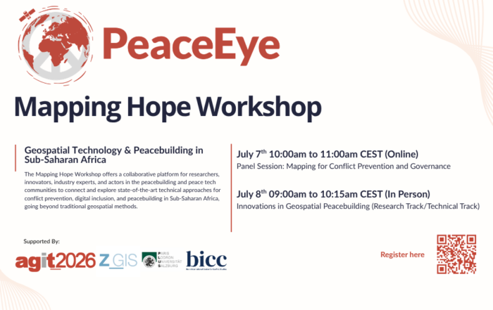
Mapping Hope Workshop (AGIT 2026)
Mapping Hope Hybrid Workshop (AGIT 2026) Geospatial Technology & Peacebuilding in Sub-Saharan Africa July 7–8, 2026 | Organized by PeaceEye FlexCo As part [...]
The Data Mosaic for Peace (The Peace Room)
The Data Mosaic for Peace This blog post highlights a recently published article in The Peace Room Substack, where PeaceEye CEO, Andreas Papp, discusses [...]

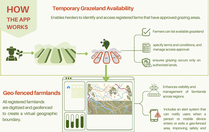
PeaceEye-FUNAAB Sign MoU on Farmer-Herder Conflict Tool
FUNAAB, Austria's PeaceEye Partner on Digital Tool to Address Farmer–Herder Conflict In a bold move to resolve the lingering farmer-herder crisis in Nigeria, [...]

From the Horse’s Mouth. Meeting with Farmers and Herders in Nigeria.
From the Horse's Mouth | Meeting with Farmers and Herders in Nigeria. Last week in Ogun State, Nigeria, PeaceEye's CEO, Andreas Papp, met [...]
latest update: March 2026

